

SOUTH COAST 2026 ROUTE MAP
ROUTE HIGHLIGHTS
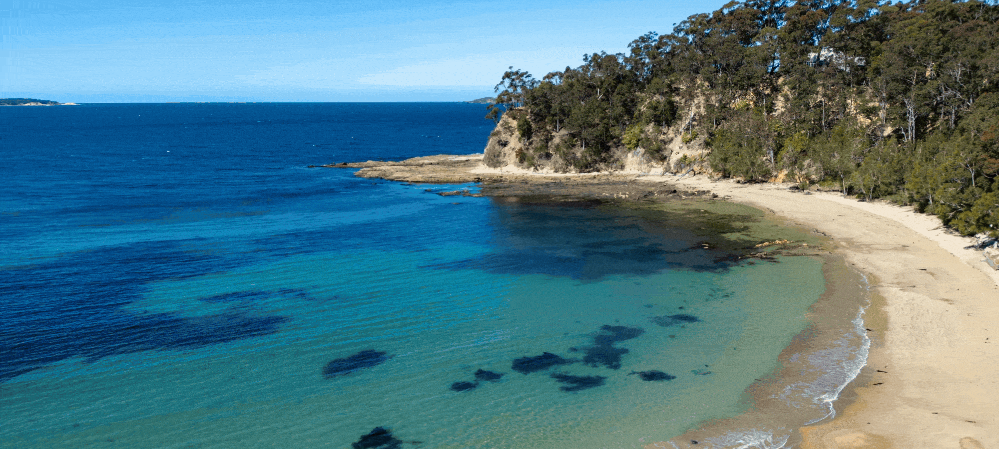
It doesn’t get more soulful than this. Our brand-new South Coast Coastrek route follows the stunning Munjip Trail along Eurobodalla’s wild coastline, where sweeping beaches, rocky headlands and peaceful bays invite you to slow down, look outward – and reflect within. Stretching between Batemans Bay and Malua Bay, this route offers an unforgettable coastal escape just a few hours from Canberra or Sydney.
You’ll journey through diverse land and sea ecosystems, weaving between bushland, beaches, bays, headlands and rock platforms, with uninterrupted ocean views around every bend. Along the way, you’ll encounter powerful artwork and stories of the Walbunja people, custodians of the world’s oldest continuing culture. Munjip means “walking together” in Dhurga language, a fitting reminder of connection, community and Country. As always, every Coastrek route is carefully curated for maximum wow-factor – natural people in, busy roads out.
Choose to hike 30km from Corrigans Beach, passing Surf Beach and Malua Bay before crossing the Finish Line at Batemans Bay, or take on the 20km route from Malua Bay via Surf Beach. The further you go, the more this spectacular coastline reveals itself – and the more meaningful every step becomes

Start: Malua Bay
Start time: From 11:30am
Finish: Batemans Bay
Duration: Up to 6 Hours

Start: Corrigans Beach
Start time: From 7am
Finish: Batemans Bay
Duration: Up to 10 Hours
THRILLING 30KM
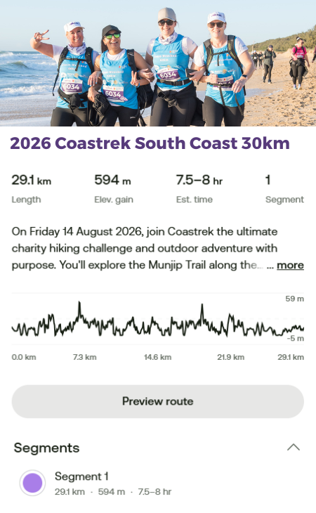
The 30km trekkers will set off from Corrigans Beach in Batemans Bay, a calm coastal bay and the perfect place to begin your South Coast journey. From here, you’ll join the Munjip Trail – a stunning coastal track whose name means “walking together” in Dhurga language – setting the tone for a day grounded in connection, community and Country.
The early kilometers wind south through Sunshine Bay, where the trail transitions between bushland paths, coastal foot tracks and sandy beach sections. Expect a mix of compact dirt, sand and rock underfoot as you weave between peaceful bays and elevated headlands, with sweeping ocean views opening up beside you. Keep an eye out for rocky platforms along the way and take care on uneven sections, particularly if conditions are damp.
You’ll reach Surf Beach for your first Luv Stop, a wide, open stretch of coastline backed by natural bushland. Take a moment to refuel, soak in the salty air and enjoy the rhythm of the ocean before continuing along the Munjip Trail towards Malua Bay. This section offers some of the most dramatic scenery of the route, with panoramic coastal views across beaches, bays and headlands – a true highlight of the day!
From Surf Beach, the trail continues south as you begin your return journey, continuing along the Munjip Trail. You’ll arrive at Malua Bay for Luv Stop 2, a beautiful crescent of sand and a welcome spot to rest the legs and enjoy the coastal atmosphere.
From Malua Bay you turn around and make your way back north back towards Surf Beach for Luv Stop 3, following familiar terrain with plenty of opportunities to reflect, reconnect and walk together. Artwork and stories along the trail invite you to look both outward to the coastline and inward to your own journey – a uniquely grounding experience.
From Surf Beach, it’s the final stretch back to Corrigans Beach, where the trail becomes gentler and the Finish Line draws closer. As you take your final steps along this spectacular section of the Eurobodalla coast, soak up the sense of achievement – you’ve explored one of NSW’s most beautiful coastal trails, rich in nature, culture and meaning. You did it!
TERRIFIC 20KM
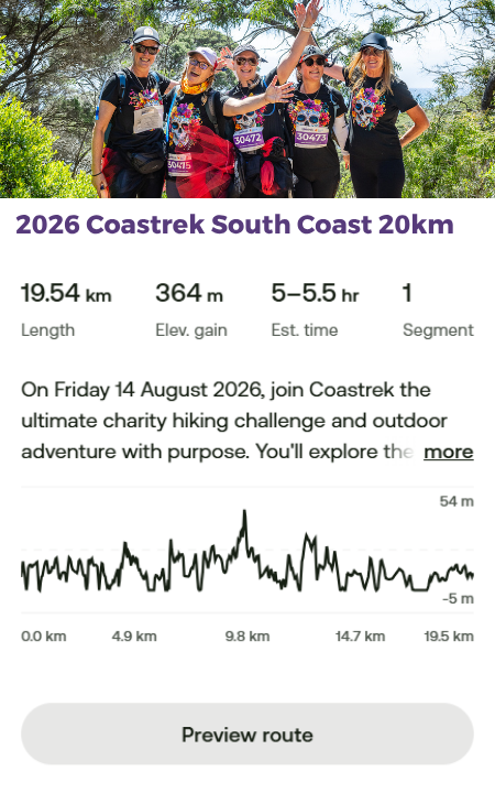
The 20km trekkers will set off late morning from Malua Bay, one of the South Coast’s most picturesque stretches of sand, with gentle waves and wide coastal views setting the scene for the day ahead. From here, you’ll join the Munjip Trail – meaning “walking together” in Dhurga language – and begin your journey north along the Eurobodalla coastline.
The trail winds through a beautiful mix of beaches, bushland, headlands and rock platforms, with ever-changing terrain underfoot. Expect sections of compact dirt paths, sand and uneven rock as you pass through Lilli Pilli -, with elevated lookouts offering sweeping views back across the coastline. Take care on rocky sections, particularly if conditions are wet.
You’ll reach Surf Beach for your Luv Stop, a welcome place to refuel and regroup before the final stretch. From here, the trail continues along familiar coastal paths, delivering a final series of ocean views and peaceful bays as you make your way toward Corrigans Beach.
The route gently guides you back into Batemans Bay, where the Finish Line awaits. Take a moment to soak it all in – the scenery, the shared journey and the achievement of walking together along one of the South Coast’s most meaningful coastal trails.
You did it!
But what about the sand, how much sand?!
30km event – approx. 10km of sand walking
20km event – approx. 5km of sand walking.
Access Coastrek maps via AllTrails App
You can access the new Coastrek South Coast 2026 route on your phone via the AllTrails App! First download the AllTrails App onto your phone via the App Store or Google Play, then click on the relevant Map links below to access the Coastrek route within the AllTrails App. The AllTrails App is FREE so you don't need to pay for it to access the map, just save it as a favourite :) But if you choose to get an AllTrails+ subscription, Coastrekkers get a one month free trial - see Goodie Bag in your Dashboard once you've signed up. With an AllTrails+ subscription, you can download the Coastrek route map and training trails for offline use (recommended!).
To save the Coastrek route as a 'favourite', click on the relevant event map link below via a desktop computer and click the ribbon icon in the top left corner. Then, open up your AllTrails app on your phone and click on the 'saved' menu item on the bottom of the screen. The route will appear there!
Click HERE for some easy to follow instructions on how to access the AllTrails map.
Hard copy - Coastrek South Coast Map Guide
Wanting to keep it old school? We still have a hard copy map guide available as a simpler alternative to the All Trails maps.
Map GPX Files - Coastrek South Coast map GPX files
Want to download the map onto your smart watch or you have an existing map app that you'd prefer to use? This is an alternative you can download and install to your preferred device or app.
Please note: All Coastrek routes are subject to change. We attempt, at all times, to adhere to the advised route. As we are immersed in nature, however, there may sometimes be circumstances beyond our control (tides, fallen trees/branches, other safety aspects as advised by local councils) that require us to slightly alter the route. In any such cases these will be clearly marked and identified on event day.
MAP DISCLAIMER: Event distances are approximate and may vary, detour or change on event day due to unforeseen circumstances such as weather, safety considerations or if Chris Hemsworth is spotted on the beach. Just kidding. Or are we?
PHOTOS: By Mark Watson & Eurobodalla Shire Council

