

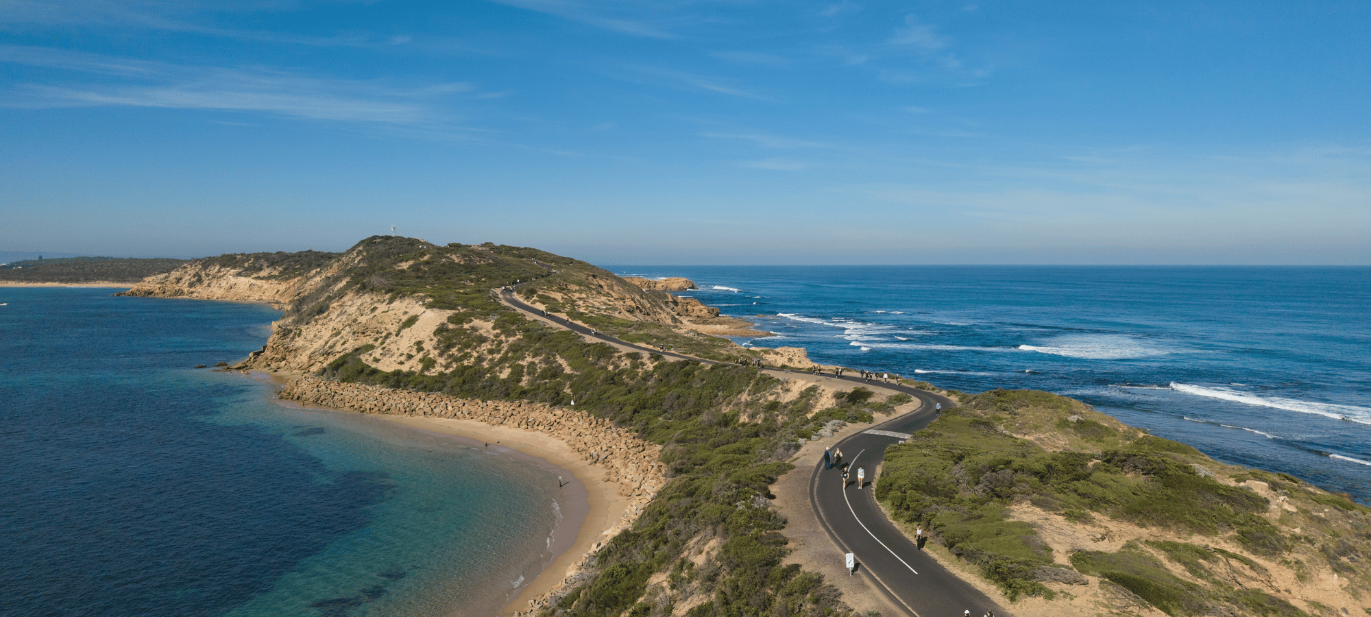
MORNINGTON PENINSULA ROUTE MAP
ROUTE HIGHLIGHTS
Ready to explore the Mornington Peninsula’s spectacular coastline? Choose a 20km, 30km or 50km Coastrek adventure – the longer you hike, the more you’ll see (and trust us, there a LOT to see)!
Just over an hour from Melbourne CBD, you’ll discover rugged coastal trails, tranquil bushland, wild beaches and some of Victoria’s most breathtaking scenery. Think salty air, big views and plenty of moments that make you stop and say “wow”.
With Start Lines at Cape Schanck Lighthouse, Point Nepean and Sorrento, and a Finish Line at Point Nepean, get ready for an unforgettable hiking challenge on one of the most picturesque coastlines near Melbourne.

Start: Sorrento
Start time: From 11:30am
Finish: Point Nepean
Duration: Up to 6.5 Hours

Start: Point Nepean
Start time: From 8am
Finish: Point Nepean
Duration: Up to 10 Hours

Start: Cape Schanck
Start time: From 6am
Finish: Point Nepean
Duration: Up to 15 Hours
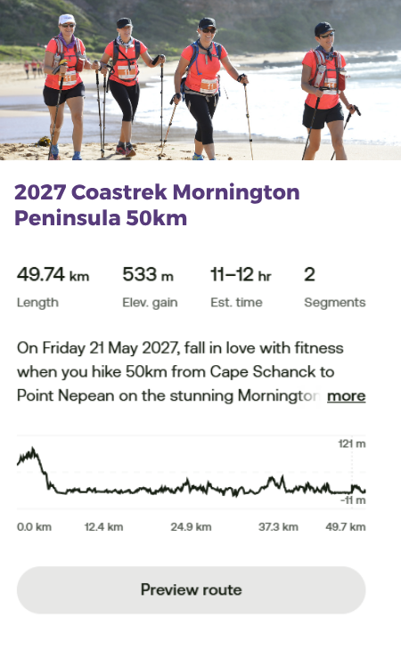
50km teams will set off at dawn from Cape Schanck Lighthouse, an iconic landmark on the southern tip of the Mornington Peninsula, embarking on one seriously epic hike near Melbourne. The route follows undulating trails through dense native scrub along The Coastal Walk track, hugging the coastline from the get-go.
You’ll tick-off the highest elevation on the route (121m) early – go you! – before descending off the track to Gunnamatta Beach. Take on 1.4km of sand before re-entering the track at the Surf Club. From there, a 3.4km soft sand trek along St Andrews Beach offers breathtaking views of the wild open ocean stretching out to Bass Strait. This is one of those moments where you’ll be very glad you brought your bestie along.
You’ll continue back on the bush track until another 1km sand walk at Number Sixteen Beach, followed by a scenic 3km trail through to Blairgowrie. From here, join Coppins Track through to Sorrento, with recommended vantage points including Diamond Bay and St Paul’s Beach lookouts – both well worth a pause to soak it all in.
Continue around Coppins Track, up to Coppins Lookout and through Sorrento Village, before crossing the Peninsula to the Sorrento-Queenscliff Ferry Terminal. This picture-perfect spot comes with sweeping views across Port Phillip Bay Heads, before you continue along the coastline on a mix of paved pathways and natural trails, including the aptly named “Millionaires Walk” (cha-ching!).
There’s some limited sand walking on Shelley Beach and Portsea Front Beach before heading inland along Butlers Track, where you’ll hit the ‘10km to go’ mark on your approach to Point Nepean National Park. Yep, you’re nearly there!
Continue to the Rifle Range Luv Stop for a refresh before heading on to Fort Nepean – the western-most tip of the Peninsula, with panoramic views across the escarpment. Follow gently sloping bushlands along Coles Track for the final descent into the Port Nepean Parade Ground.
And then? Finish line. Friends. High fives. That very satisfying feeling of having just walked 50km along one of Victoria’s most spectacular coastlines.
Woohoo, you did it!
But what about the sand, how much sand?!
50km event – approx. 4km of sand walking
Please note: All Coastrek routes are subject to change (thank you nature!) and distances have a variance or +/- 3km*
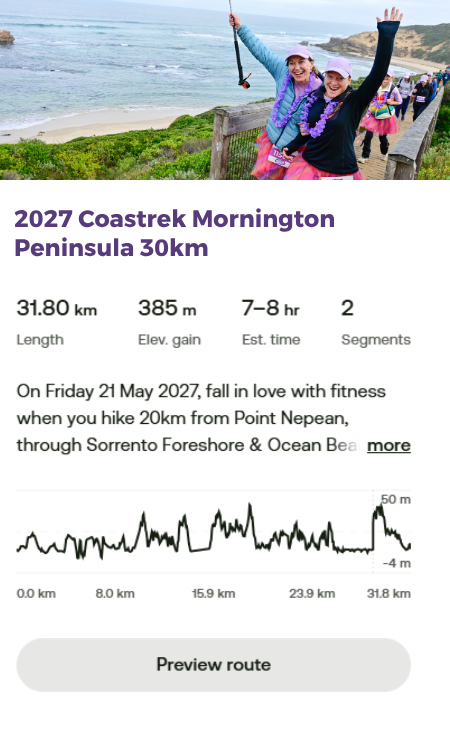
30km teams will set off at sunrise on one of the most scenic hikes near Melbourne, following a clockwise loop of the Peninsula, that starts and finishes at Point Nepean. (Return trekkers, take note – in 2027, we’re hiking clockwise, not anticlockwise!).
Follow The Bay Train along the bay side of the Peninsula, passing the Sorrento-Queenscliff Ferry Terminal – a picture-perfect spot with stunning views across Port Phillip Bay Heads. From here, continue along the coastline on a mix of paved pathways and natural trails, including the aptly named “Millionaires Walk” (cha-ching!).
Cross over to the back side of the Peninsula via the Tuckey Trial to join Coppins Track. Continue along Coppins Track to Sorrento SLSC before hitting the wild waves of Portsea back beach for 1.5km of slopey, slinky, soft sand to Portsea Surf Club. Sandy shoes? Probably. Worth it? Absolutely.
Join the Farnsworth Track to London Bridge Lookout before re-entering Point Nepean National Park at Wilson Folly.
Head inland along Butlers Track, where you’ll reach the ‘10km to go’ mark on your approach to Point Nepean National Park. Double digits are officially behind you!
Continue on to the Rifle Range ‘Luv Stop’ for a well-earned refresh before heading to Fort Nepean – the western-most tip of the Peninsula, with full panoramic views across the escarpment. Soak up the scenery, take a breath and enjoy the fact that you’ve made it this far.
From here, it’s a gentle bushland descent into the Port Nepean Parade Ground and across the Finish Line – where high gives, happy tears and that unbeatable “WE ACTUALLY DID IT” feeling await.
Woohoo, you did it!
But what about the sand, how much sand?!
30km event – approx. 2km of sand walking
Please note: All Coastrek routes are subject to change (thank you nature!) and distances have a variance or +/- 3km*
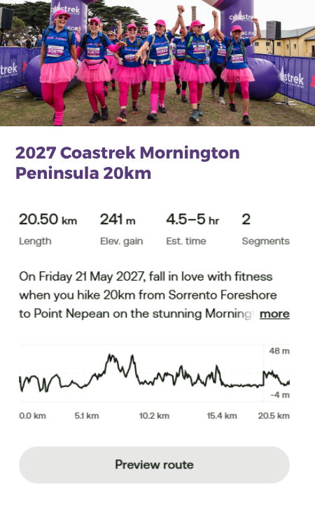
20km teams will set off at midday from Sorrento Front Beach, near the Sorrento- Queenscliff Ferry Terminal – a picture-perfect spot with sweeping views across Port Phillip Bay Heads. And what better way to kick things off than with a little sea breeze and a whole lot of coastline?
The route follows the coastline on a mix of paved pathways and natural trails, including the aptly named ‘Millionaires Walk’ (cha-ching!), offering a dreamy blend of coastal views, natural beauty and a little Mornington Peninsula magic.
There’s some limited sand walking on Shelley Beach and Portsea Front Beach before heading inland along Butlers Track, where you’ll hit the – ’10km to go’ mark on your approach to Point Nepean National Park. Halfway there!
Continue on to the Rifle Range ‘Luv Stop’ for a well-earned refresh before heading to Fort Nepean – the western-most tip of the Peninsula, with full panoramic views across the escarpment. Take a moment to soak it all in before tackling the final stretch.
The journey concludes with a gentle bushland descent along Coles Track into the Port Nepean Parade Ground and across the Finish Line – cue the high fives, happy faces and very well-earned celebration!
Woohoo, you did it!
But what about the sand, how much sand?!
20km event – approx. 1km of sand walking
Please note: All Coastrek routes are subject to change (thank you nature!) and distances have a variance or +/- 3km*
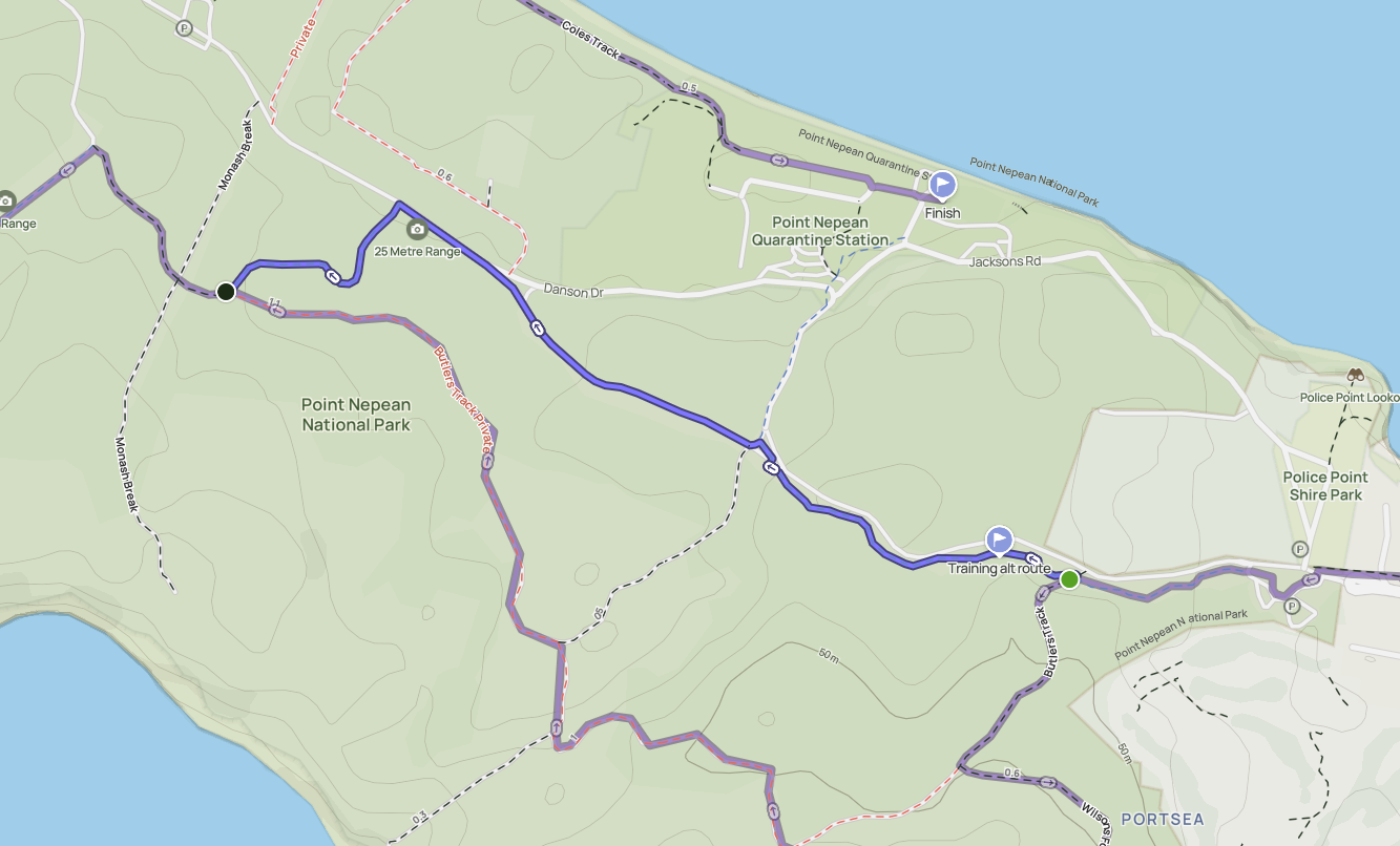
Training Detour: PLEASE NOTE: Sections of the Butlers Track will only be open on event day.
- Stay on the walking path on the left-hand-side of Defence Road
- After approx. 1.5km on Defence Road, turn left on Range Area Walk. Follow Range Area Walk until Butlers Track and turn right. You are now back on the event day route!
Access Coastrek maps via AllTrails App
You can access the new Coastrek Mornington Peninsula 2027 route on your phone via the AllTrails App! First download the AllTrails App onto your phone via the App Store or Google Play, then click on the relevant Map links below to access the Coastrek route within the AllTrails App. The AllTrails App is FREE so you don't need to pay for it to access the map, just save it as a favourite :) But if you choose to get an AllTrails+ subscription, Coastrekkers get a one month free trial - see Goodie Bag in your Dashboard once you've signed up. With an AllTrails+ subscription, you can download the Coastrek route map and training trails for offline use (recommended!).
To save the Coastrek route as a 'favourite', click on the relevant event map link below via a desktop computer and click the ribbon icon in the top left corner. Then, open up your AllTrails app on your phone and click on the 'saved' menu item on the bottom of the screen. The route will appear there!
Click HERE for some easy to follow instructions on how to access the AllTrails map.
Hard copy - Coastrek Mornington Peninsula Map Guide
Wanting to keep it old school? We still have a hard copy map guide available as a simpler alternative to the All Trails maps.
Map GPX Files - Coastrek Mornington Peninsula map GPX files
Want to download the map onto your smart watch or you have an existing map app that you'd prefer to use? This is an alternative you can download and install to your preferred device or app.
Please note: All Coastrek routes are subject to change. We attempt, at all times, to adhere to the advised route. As we are immersed in nature, however, there may sometimes be circumstances beyond our control (tides, fallen trees/branches, other safety aspects as advised by local councils) that require us to slightly alter the route. In any such cases these will be clearly marked and identified on event day.
MAP DISCLAIMER: Event distances are approximate and may vary, detour or change on event day due to unforeseen circumstances such as weather, safety considerations or if Chris Hemsworth is spotted on the beach. Just kidding. Or are we?

