

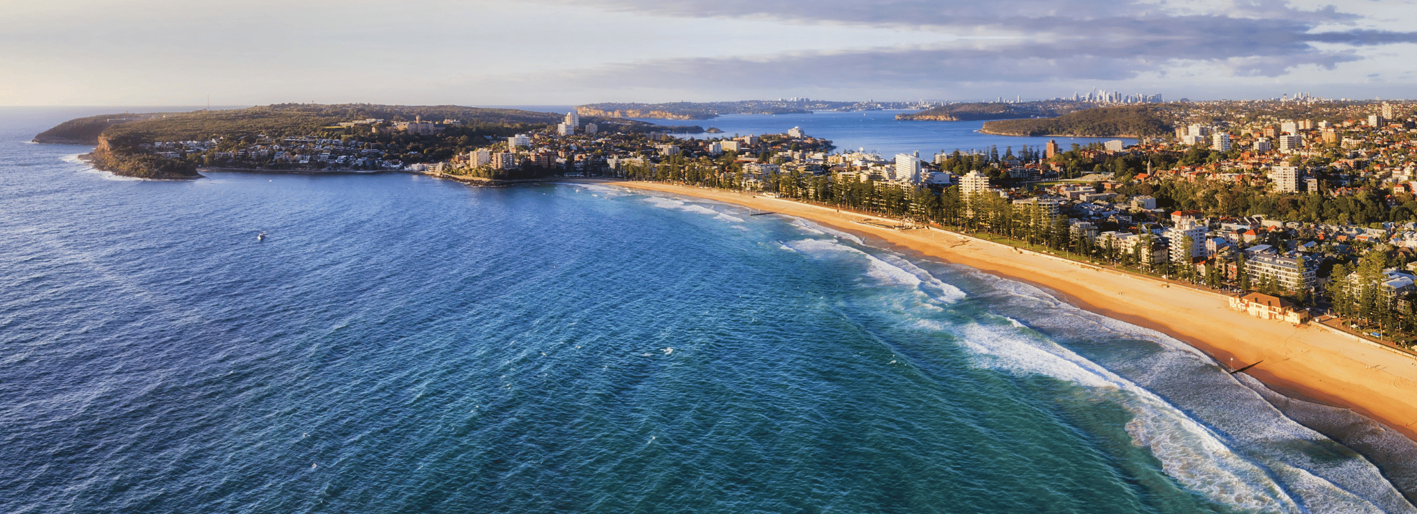
SYDNEY'S NORTHERN BEACHES ROUTE MAP
Attention trekkers! Due to weather and surf conditions, we are moving the Shelly Beach Luv Stop to Manly Life Saving Club at South Steyne as advised by council. A re-route will also be in place along Bower St. Don't worry! There will be plenty of Event staff on hand to direct you and lots of signage. Make sure you let your Support crew know and download the latest map from AllTrails below.
ROUTE HIGHLIGHTS
We always put the ‘coast’ in Coastrek, and our Sydney route really shines – breathtaking views and natural landscapes are in, busy roads and concrete jungles are out! Our goal is to get you moving out in nature, and we plan our trails with care and flair to make sure you experience the full Coastrek magic.
This Northern Beaches hiking adventure between Palm Beach and Manly shows off Sydney in all her world famous beaches and harbourside glory. You’ll take in coast-hugging trails, iconic golden sand beaches, scenic headlands and clifftop lookouts with some of the most jaw-dropping panoramic views of Sydney’s spectacular coastline.
It’s an idyllic paradise just north of Sydney's CBD, so why not linger longer? Stay for a rejuvenating weekend and soak up Manly’s buzzing bars, cool cafes and oceanfront restaurants – perfect for your well-earned post-trek celebration!

Date: 27 March 2026
Start: Long Reef
Start time: From 11am
Finish: Manly
Duration: Up to 6 Hours
*Actual distance: 18.7km

Date: 27 March 2026
Start: Mona Vale
Start time: From 7am
Finish: Manly
Duration: Up to 10 Hours
*Actual distance: 29.5km

Date: 27 March 2026
Start: Palm Beach
Start time: From 6am
Finish: Manly
Duration: Up to 15 Hours
*Actual distance: 47.9km
HAVEN'T SIGNED UP YET?
Sydney 2026 is SOLD OUT! Get onto the Registered Interest list for 2027 ASAP to have the best chance of getting a spot in 2027.
FABULOUS 50km
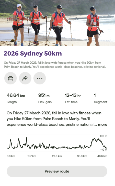
*Actual distance: 46.6km
Please note: The Coastrek route is subject to change.
50km route - Our intrepid 50km trekkers will set off at dawn from Palm Beach, heading north to the iconic Barrenjoey Headland and heritage lighthouse – Sydney’s northernmost point. Kickstart your journey with a sunrise and epic views across Pittwater and the Pacific, before looping back and hitting your first beach stretch at Palmy.
The trail continues along the stunning coast to Whale Beach, around Bangalley Headland, and on to Avalon Beach – where your first Luv Stop awaits at the 11km mark. Grab some fuel, stretch it out and get ready to power on!
Next up: Bilgola Headland and a sandy section through Bilgola Beach, then on to undulating trails and breezy boardwalks to Newport Beach. Look out for hang-gliders soaring above and surfers catching waves below – you’re in peak Sydney territory now.
Keep following the coastline until you hit Mona Vale Beach and the 18.5km mark Luv Stop – cue hydration, smiles, and high-fives.
Only the 50km legends get to experience the magic of the Palm Beach to Mona Vale section. It’s glorious, it’s coastal, and it’s all yours!
From Mona Vale, kick into gear with a golden stretch of sand, then weave past Warriewood Beach and around Narrabeen Headland. Next comes the sandy link between North Narrabeen and Collaroy, followed by jaw-dropping views from Long Reef Lookout and your Luv Stop at the Surf Club – 30kms down, 20kms to go - you’re more than halfway there!
Hug the shoreline on bush trails and paved paths to Dee Why. Take the Cobblers Walkway around Curl Curl Lagoon, then cruise along the boardwalk to Curl Curl Beach, across the headland, and onto the sand at Freshwater Beach. You’re getting close now.
Roll through Queenscliff and onto Marine Parade alongside the world-famous Manly Beach before landing at the final Luv Stop at Manly Life Saving Club at South Steyne. Reapply sunscreen, breathe in that salty air and celebrate – just 10km to go!
With a final gentle climb through North Head’s bushland, you’ll reach one of the day’s most awe-inspiring lookouts, with dramatic cliffs and city skyline views. Soak it in – you’ve earned it.
Descend into the heart of Manly and on to the buzz of Manly Cove, passing Manly Wharf and an array of cafes, bars and restaurants. Follow the Esplanade and straight onto the Finish Line at Manly Cove (adjacent to The Espy).
Woohoo, you did it!
But what about the sand, how much sand?!
50km event – approx. 10km of sand walking
THRIlling 30km
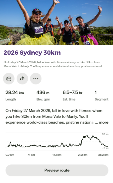
*Actual distance: 28.2km
Please note: The Coastrek route is subject to change.
30KM ROUTE MAP
30km route - Trekkers, you’re off at sunrise from Mona Vale, launching your day with an energising sand stretch to get the legs pumping! From here, the coastal path takes you past Warriewood and Narrabeen Headland before landing you on the beach between North Narrabeen and Collaroy.
Get ready for the spectacular Long Reef Lookout, then treat yourself to a well-earned rest at the 10km mark Luv Stop at Long Reef Surf Club.
Then it’s on through bush and beach from Dee Why, around Curl Curl Lagoon - via the scenic Cobblers Walkway - and back onto the coast at Curl Curl Beach. Round the headland and stroll the sandy stretch at Freshwater, through Queenscliff and onto Marine Parade with world-famous Manly Beach to your left.
You’ll reach the picturesque Luv Stop at Manly Life Saving Club at South Steyne. Time to stretch, breathe, and feel strong – 20km down, just 10km to go!
With a final gentle climb through North Head’s bushland, you’ll reach one of the day’s most awe-inspiring lookouts, with dramatic cliffs and city skyline views. Soak it in – you’ve earned it.
Descend into the heart of Manly and on to the buzz of Manly Cove, passing Manly Wharf and an array of cafes, bars and restaurants. Follow the Esplanade straight to the Finish Line at Manly Cove (adjacent to The Espy).
Woohoo, you did it!
But what about the sand, how much sand?!
30km event – approx. 5km of sand walking
TERRIFIC 20KM
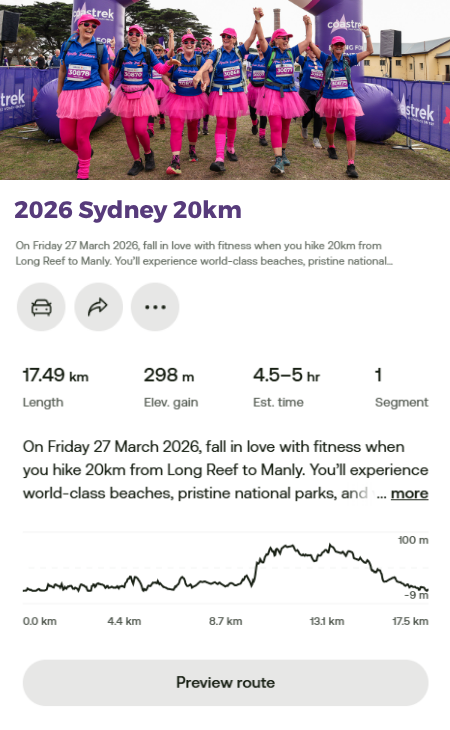
*Actual distance: 17.5km
Please note: The Coastrek route is subject to change.
20KM ROUTE MAP
20km route - Late risers, rejoice! The 20km crew kicks off from Long Reef at 11am, with plenty of trail excitement ahead.
You’ll hug the coastline on winding bush paths through Dee Why, before looping around Curl Curl Lagoon via the Cobblers Walkway and jumping back onto the beach boardwalk at Curl Curl. Round the headland and hit the sand at Freshwater, forging ahead to Queenscliff.
Stroll along Marine Parade beside the legendary Manly Beach before arriving at the Luv Stop at Manly Life Saving Club at South Steyne. Time for a reset – you’re halfway home!
With a final gentle climb through North Head’s bushland, you’ll reach one of the day’s most awe-inspiring lookouts, with dramatic cliffs and city skyline views. Soak it in – you’ve earned it.
Descend into the heart of Manly and on to the buzz of Manly Cove, passing Manly Wharf and an array of cafes, bars and restaurants. Follow the Esplanade and straight on to the Finish Line at Manly Cove (adjacent to The Espy).
Woohoo, you did it!
But what about the sand, how much sand?!
20km event – approx. 1.5km of sand walking
Access Coastrek maps via AllTrails App
You can access the new Sydney 2026 route on your phone via the AllTrails App! First download the AllTrails App onto your phone via the App Store or Google Play, then click on the relevant Map links below to access the Coastrek route within the AllTrails App. The AllTrails App is FREE so you don't need to pay for it to access the map, just save it as a favourite :) But if you choose to get an AllTrails+ subscription, Coastrekkers get a one month free trial - see Goodie Bag in your Dashboard once you've signed up. With an AllTrails+ subscription, you can download the Coastrek route map and training trails for offline use (recommended!).
To save the Coastrek route as a 'favourite', click on the relevant event map link below via a desktop computer and click the ribbon icon in the top left corner. Then, open up your AllTrails app on your phone and click on the 'saved' menu item on the bottom of the screen. The route will appear there!
Click HERE for some easy to follow instructions on how to access the AllTrails map
Hard copy - Coastrek Sydney Map Guide
Wanting to keep it old school? We still have a hard copy map guide available as a simpler alternative to the All Trails maps.
Map GPX Files - Coastrek Sydney map GPX files
Want to download the map onto your smart watch or you have an existing map app that you'd prefer to use? This is an alternative you can download and install to your preferred device or app.
*MAP DISCLAIMER: All Coastrek routes are subject to change and distances have a variance or +/- 3km. Choose the distance challenge that’s right for you, and see the route maps for details. It’s all part of the adventure and being immersed in nature! The Coastrek routes may also detour or change on Event Day due to unforeseen circumstances. We attempt, at all times, to adhere to the advised route however there may be circumstances beyond our control such as weather, tides, fallen trees/branches, or other safety aspects as advised by local councils that require us to alter the route. In any such cases these will be clearly marked and identified on Event Day, and communicated to trekkers beforehand where possible.

